What to do and see in Tateyama-machi, Chubu: The Best Nature & Parks
Discover the best top things to do in Tateyama-machi, Japan including Mt. Tateyama, Tateyama Mountain Range Traversal, Kurobe Dam, Shomyo Falls, Mikurigaike Pond, Daikanbo, Murododaira, Mt. Okudainichidake, Jigoku Valley, Dojo Lake.
Restaurants in Tateyama-machi
1. Mt. Tateyama
Overall Ratings
5.0 based on 135 reviews
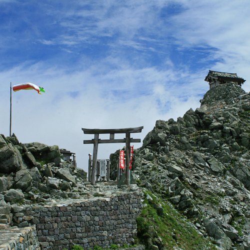
Mt. Tateyama is a mountain located in the southeastern area of Toyama Prefecture, Japan. It is one of Japan's "Three Holy Mountains" along with Mt. Fuji and Mt. Haku. Mt.Oyama is one of the three peaks that make up Mt.Tateyama. There is "Oyama Shrine" on the summit of Oyama and a priest there can pray for you with 500JPY from July to September. You can see Mt.Fuji and Japan sea from the summit if the weather is good! It takes about 2 hours from Murodo terminal to the summit of Oyama one way. As it is a mountain climbing course, equipment such as trekking shoes, stocks, and warm clothes even in summer are required.
Reviewed By Eevon88
We hiked up Mt Tateyama on 8th May 2018. We started our journey at Toyama Chitetsu Railway station departing at 5.26am, exchanged our tickets (JR tateyama promo tix 9000 yen) at Tateyama station, and took the 1st cable car at 7am. Then, switched transport to Tateyama highland bus and reached Murudo station around 8.15am. We did approach the customer service counter to get some guides as we have no clue how to get to th summit, however we were given assurance that path is footprinted and many has gone up already. No registration required. We started our hike at 8.30am, putting on our crampons, prepping hiking sticks and most importantly, sunglasses as the reflection from the snow is very glaring. We found poles sticking out from the snow and that was the guide to lead to the 1st resthouse. The snow was thick and deep, but crampons did help to grip the snow. It was a relaxing climb, but there were few steeper slopes. We were amazed by the view as we were surrounded by snow mountains. There was this little stinch of sulphuric smell in the air and the snow has yellowish patchy colours that represent the mixture of sulphur with ice. Once we reached the first resthouse, we kept our crampons as the rest of the hike was loose rocks and gravel. There wasnt much of a path at the rocky areas, and you have to be careful where you step as some promising rocks are shaky or will give way due to your weight. In between the rocky path there was a very small shrine. We made our prayers and continued our journey. We reached a false peak only to find a longer path up the summit. After the false peak, the path is zig-zagged. Please be careful not to step on the frost as it could be slippery. Initially, halfway up from the false peak, we took a wrong turn to the right and reached a frosty steep slope. We decided to turn back, but another hiker who is descending pointed a different direction and we somehow found another path up the summit. Finally, we reached the summit and the view was amazing!!! Took us 3 hours to get up there from Murudo station! The resthouse at the summit was not operating and buried in snow. We took our time to savour the moment and just spoil ourselves with the view and coldddd wind. Please prepare warm clothings and waterproof shoes as it could get very cold and windy up there. Amazing experience and it was our very first alps snow hike!!!
2. Tateyama Mountain Range Traversal
3. Kurobe Dam
Overall Ratings
4.5 based on 757 reviews
Reviewed By PeterthePauper - Ulsan, South Korea
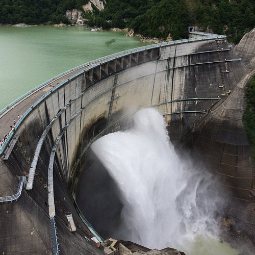
Over the space of a few days, I managed to extract the maximum value from a JR Central Alpine-Takayama-Matsumoto Area 5-Day Pass by making two separate visits to the Kurobe Dam; each from opposing directions. The first visit (from Toyama) was memorable for the sheer variety of transport; the Toyama Chiho Railway Alpine Route, Tateyama Cable Car, Tateyama Highland Bus, Tateyama Tunnel Trolley Bus, Tateyama Ropeway & Kurobe Cable Car. Each mode of transport unique and entertaining in its' own right, and having set-off from Toyama before 08:00am on a day that started overcast with a light drizzle, it was only fitting that my first glimpse of Kurobe Lake and Dam (some 3 1/2 hours later) was in the exhilarating descent from the zero visibility of Daikanbo on the Tateyama Ropeway into the beautiful sunshine that bathed Kurobe Dam. Limiting myself to only an hour at the Dam, I headed back on the long trek to Toyama. With the improved visiblity, I was able to spend more time at each of the interchanges (e.g.: Kurobedaira, Daikanbo & Murodo), viewing and photographing the sights/scenery. 2-days later I revisited Kurobe Dam; this time from the Shinano-Omachi side. The Dam can be reached from Matsumoto in a little over 2-hrs using JR Oito Line, Local Bus & Kanden Tunnel Electric Bus. Arriving from Ogizawa by Electric Bus, you are faced with a choice; walking in a general downward direction to the tunnel entrance at top-of-dam-level (est. 5-mins), or ascending up some steps to the Dam Observation Deck (est. 7-mins). I would recommend the latter as it gives by far the best vantage point to view the dam itself and the ability to then descend the external stairs back to top-of-dam-level and the Rainbow Terrace below that. The shorter journey to the dam from the Shinano-Omachi side is less interesting that the journey from Toyama but enabled more time to be spent at the dam itself as well as the opportunity to revisit the Tateyama Ropeway up to Daikanbo (the highlight of my visit 2-days before). Despite spending 2-hrs at the Kurobe Dam, I wished in hindsight that I had spent longer and explored the Kurobe Lake further. Maybe next time!
4. Shomyo Falls
Overall Ratings
4.5 based on 174 reviews
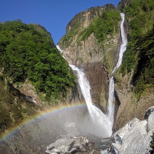
Shomyo Falls falls 350m and the difference in elevation is biggest in Japan. That's why it looks so powerful and it is valuable to see it. In autumn from late October to early November, Shomyo Falls are sYou can see a small part of Shomyo Falls from the parking space, but you should go to observation deck by walking about 30 minutes to see whole of the fall.urrounded by colorful leaves. This autumn season would be crowded, so sometimes it is difficult to find empty parking space in weekend. Besides, you can not go to Shomyo Falls from late Novemver to Spring because the road to there would be closed. You can see a small part of Shomyo Falls from the parking space, but you should go to observation deck by walking about 30 minutes to see whole of the fall.
Reviewed By unescotravelbug - Wooster, United States
Shomyo Falls situated in Tateyama, Toyama Prefecture, is considered the tallest waterfall in Japan by the period of running water and is one of the significant attractions of Tateyama Kuorbe Alpine Route. Shomyo Falls can be accessed by Tateyama’s sightseeing bus at outside of Toyama Chiho Railway Tateyama Station during the Spring to late Fall season when Alpine Route is opened to the visitors. Each year after the heavy snow begins to melt in the late Spring, visitors can view the magnificent scenes of high-volume water continuingly rushing down from 350 meters high above, created thundering effects and colorful rainbow sights on the sunny days. Hannoki Falls flows down beside it actually situated at the higher position at 497 meters but waterfalling is only limited to April through July due to the origin of the melting snow from Midagahara plateau wet land. It’s paired with Shomyo Fall as a twin-waterfall. The winter heavy snow sometimes would cause the Somen Waterfall to appear to the right of the Hannoki Falls after the snow melted. If you visit at the right time you might be able to catch such extraordinary phenomenon that three waterfalls are seen spontaneously flowing down beside each other. There are two separate viewing decks and a covered rest area where you can watch the waterfalls up close, but you must take stone steps going up which can be a challenging task for people with mobility concerns. After you get off the final bus stop there is a rest area and toilet facility. To reach the Falls from the bus stop you can enjoy approx. 30 min. scenic walk with the stream of rushing water and lush greenery or autumn foliage along the way. You will see the famous part of the mountain range in this area appeared to be in shear cut bold cliff faces due to the volcanic erosion. Shomyo Falls National Park is closed during winter but other three seasons’ natural scenery are not to be missed. Bus ride from Tateyama Chiho Railway Station is about 15 minutes served by Tateyama Kurobe Kankou (TKK) bus, and then 30 minutes by foot. Bus service schedules between the Falls and Tateyama Station are infrequent so be sure to keep track of time during the visit. The bus fare is 500 yens each way. I highly recommend that you include the Shomyo Falls visit as part of your Tateyama-Kurobe Alpine Route itineraries if time allowed. It’s difficult to manage the Alpine Routes and Shomyo Falls all in one day. So I recommend that you either stay extra day in Tateyama (which is a small charming town with relaxing atmosphere and plenty of greenery) or Toyama and make it a half day trip before or after the Alpine Route journey.
5. Mikurigaike Pond
Overall Ratings
4.5 based on 233 reviews
Mikurigaike Pond is a volcanic lake in Murodo that looks like a symbol of Tateyama. The circumference of the pond is 631m and there is a walking path, so you can walk in about an hour. You may see Raicho bird which is Japan Natural Monument near the pond. It is completely covered with snow from April to June.
Reviewed By AndyDingo
One of the stops on the Alpine railway. We did a day trip from Toyama. To get here it is via train, cable-way and bus. Note it is not open during winter.
6. Daikanbo
Overall Ratings
4.5 based on 115 reviews
Daikanbo is a station located on a cliff. Therefore, you can enjoy magnificent scenery from a terrace in the station. Especially in the middle of October, the best autumn color can be seen from Tateyama Rope-Way between Daikanbo and Kurobedaira.
7. Murododaira
Overall Ratings
4.5 based on 69 reviews
Murododaira is located at an altitude of 2,450m, it is the center of the Alpine Route and a tourist base. There are magnificent mountains in front of you and a walking path is also in place. You can see beautiful “Mikurigaike Pond” the deepest alpine lake in the Japanese Alps, and “Hell Valley” where you can see volcanic activity. You should feel wonderful nature with great force. Murododaira is covered with snow until June, so you had better to bring snow boots to walk around.
Reviewed By kimitakas - Taichung, Taiwan
Murododaira is a highlight of Kurobe Tateyama alpine route and the final destination of many tourists. Panoramic view of mountains covered with snow is beyond description. It is amazingly beautiful. Such a scenery is like that of Switzerland or Canada. Good is that it is easily accessible for everyone. If you walk around just Murododaira, you don’t need special equipment.


